15 Hidden Gems in San Francisco — beyond the postcard
A city that performs visibility while concealing its best material in plain sight
L
Una guida di
Lena Hofmann
Aggiornata il
27 maggio 2026
Lettura
12 minuti
Comprende
15 luoghi · mappa interattiva
★ Guida d'Italia 2026
Pianifica con cura. Viaggia più a fondo.
1.3M+ luoghi curati nel mondo, mappe offline e itinerari intelligenti — tutto in un'app gratuita.
1.3M+ luoghiMappe offlineItinerari AIGratis
San Francisco has a peculiar talent for making you feel like you've discovered something while simultaneously selling that discovery to forty thousand other people. The Golden Gate Bridge is not hidden. Neither is the fog, the sourdough mythology, or the particular shade of melancholy that settles over the Mission District on a Tuesday afternoon. And yet — and this is the thing about cities that genuinely reward attention — familiarity is not the same as understanding. A place can be photographed ten million times and still hold something back. The cable cars, for instance, have been on every travel poster since roughly the Eisenhower administration, and most visitors ride them once, check a box, and move on. What they miss is the mechanical philosophy underneath the street — the cables running continuously whether or not a car is attached, a kind of civic faith in perpetual motion. That gap between the postcard version of a place and its actual texture is what this list tries to close. Some of these entries are genuinely obscure. Others are technically famous but functionally invisible, walked past daily by people who think they've already seen them. The criterion was never rarity for its own sake. It was the specific feeling of arriving somewhere and thinking: how did I not know this was here? San Francisco produces that feeling more reliably than almost any city its size. You just have to be willing to look slightly to the left of where everyone else is pointing.
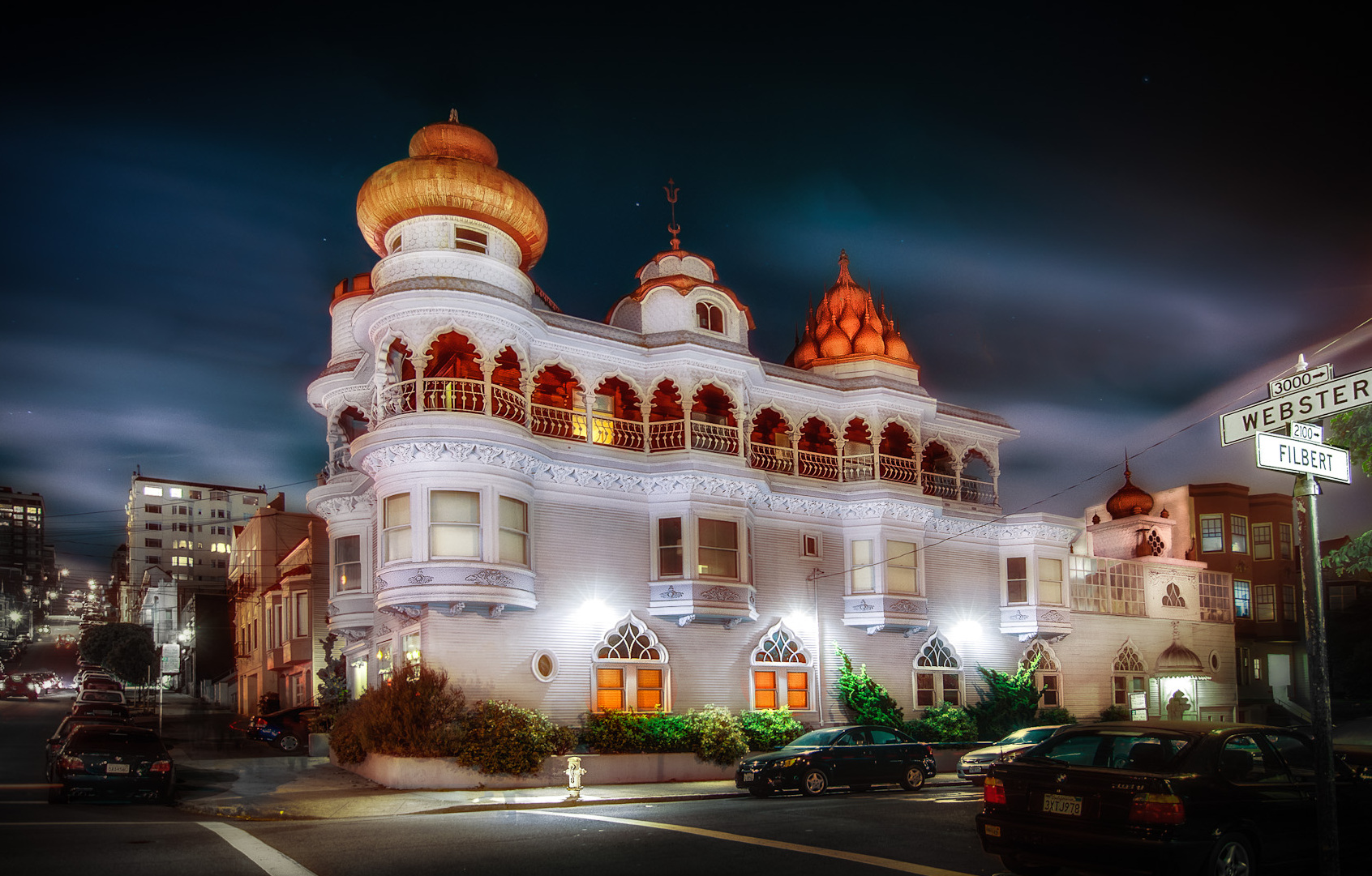
There is a building in the Western Addition that appears to have been designed by a committee representing every civilization simultaneously, and somehow it works. The Vedanta Temple is crowned by a rusty red onion dome that nods toward the Mughal tradition, while its towers borrow from medieval European turrets and its overall silhouette suggests a Victorian manor that took a very long detour through Rajasthan. Built in 1906, it is one of the oldest Hindu temples in the western United States, and the eclecticism is entirely intentional — a physical argument that all religious traditions are paths toward the same destination. Most people drive past it on Webster Street, register something unusual in their peripheral vision, and keep going. That peripheral vision is worth following.
Il consiglio del team
The temple occasionally holds public lectures and meditation sessions open to visitors of all backgrounds. Arrive early and stand across the street to take in the roofline before you enter — the full effect is architectural, not just spiritual.
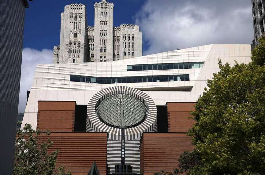
Mario Botta's 1995 building for SFMOMA announced itself with a cylindrical skylight that bisects the top floor — a stroke of architectural theatre that the institution has never quite stopped living up to. The permanent collection is particularly strong in American 20th-century sculpture and photography, two disciplines that tend to get overshadowed by the louder claims of painting. What gets missed, even by regular visitors, is the quality of the lower floors on a weekday morning when the school groups haven't arrived yet and the light through that central oculus is doing its slow diagonal work across the atrium. The 2016 expansion by Snøhetta added considerable square footage without diluting the original building's conviction. It remains one of the most intellectually serious art institutions on the West Coast.
Il consiglio del team
The third floor's photography galleries are often less crowded than the headline exhibitions. The museum's free admission on certain evenings draws a different, more local crowd — worth timing your visit accordingly.
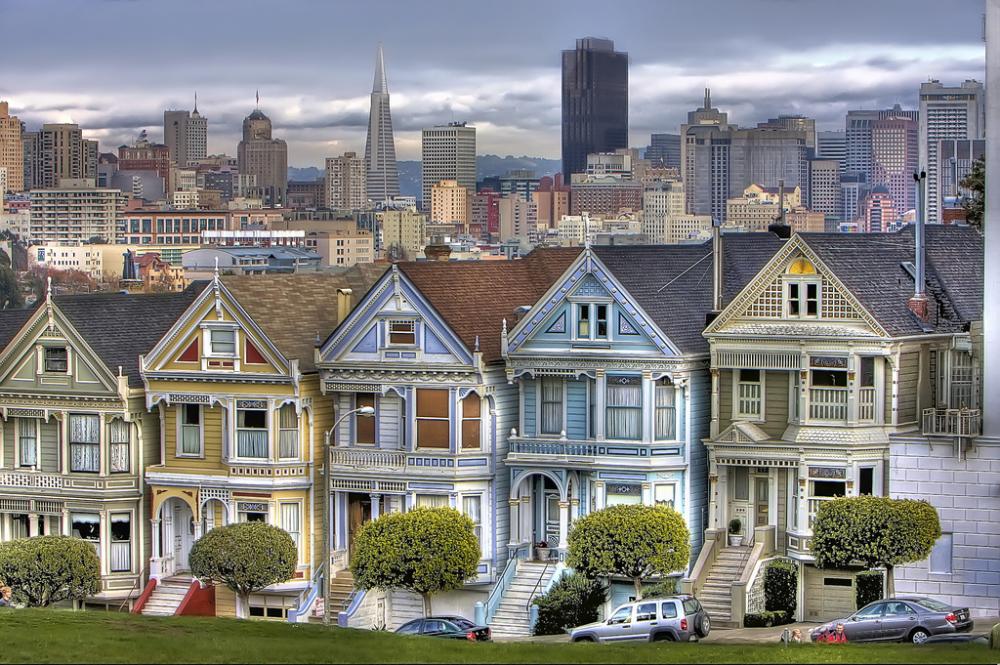
The term 'Painted Ladies' was coined specifically for San Francisco's brightly painted Victorian and Edwardian houses, and the most celebrated row faces Alamo Square with the downtown skyline stacked behind it like a stage flat. Tourists congregate at the park's eastern edge for the canonical photograph, which means they are facing away from the rest of the square and missing the broader neighbourhood context entirely. The real education is in walking the surrounding streets — Steiner, Pierce, Hayes — where the same architectural vocabulary continues without the crowd. Each house is essentially a Victorian-era argument about status expressed through millwork and colour theory. The Eastlake, Italianate, and Queen Anne styles sit side by side, and the cumulative effect is less picturesque than it is philosophically interesting.
Il consiglio del team
Walk two blocks north of the main viewpoint to find equally elaborate examples with almost no other visitors. The houses on the 700 block of Steiner are particularly well-preserved and rarely photographed.
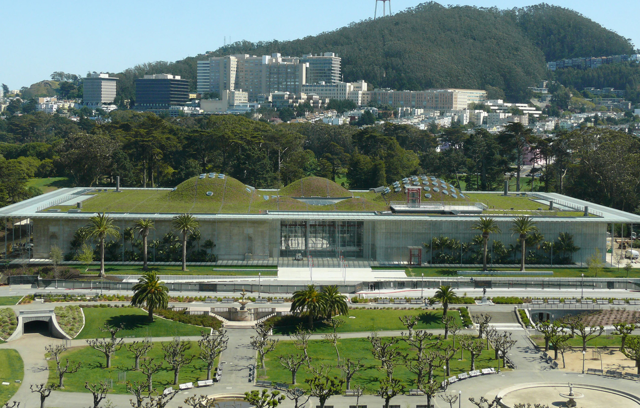
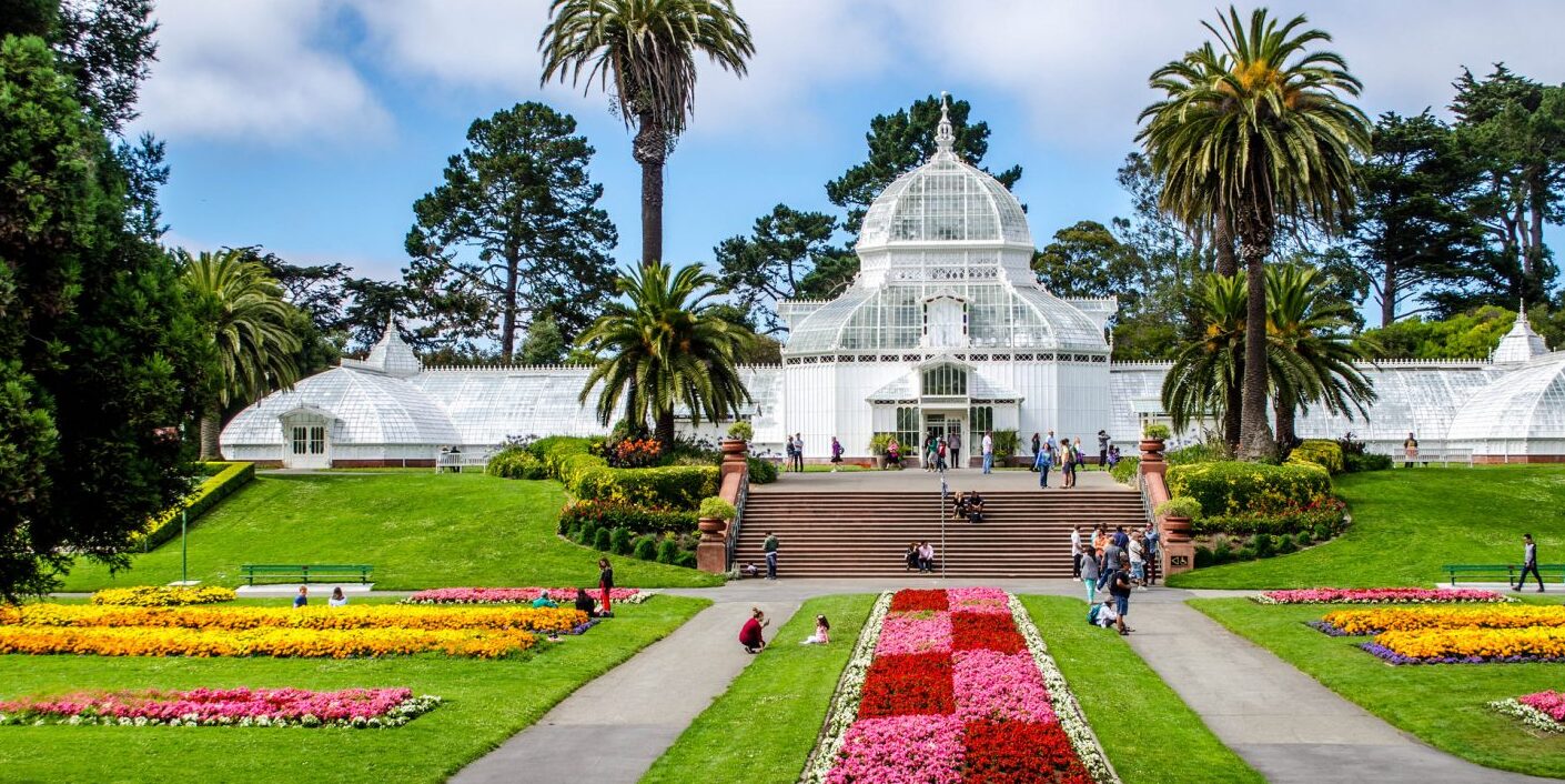
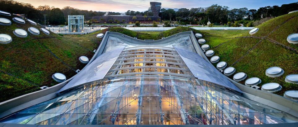
Renzo Piano's decision to turn the 2.5-acre roof of the California Academy of Sciences into a living exhibit is the kind of idea that sounds gimmicky until you're standing on the undulating green surface and realising that it genuinely replicates the topography of the San Francisco hills. The roof hides a planetarium dome and a rainforest sphere beneath its planted surface, and the building's passive cooling system means the whole structure breathes in a way that conventional museum buildings don't. From a distance, the roofline dissolves into Golden Gate Park so completely that the building seems to have grown there rather than been constructed. Piano described it as a piece of California landscape lifted slightly off the ground — which is either an architect's self-congratulation or an accurate description, depending on which side of the building you're standing on.
Il consiglio del team
The living roof is partially visible from the park's Music Concourse without paying admission. Thursday evening NightLife events offer adults-only access to the building in a noticeably different atmosphere from the daytime family crowds.
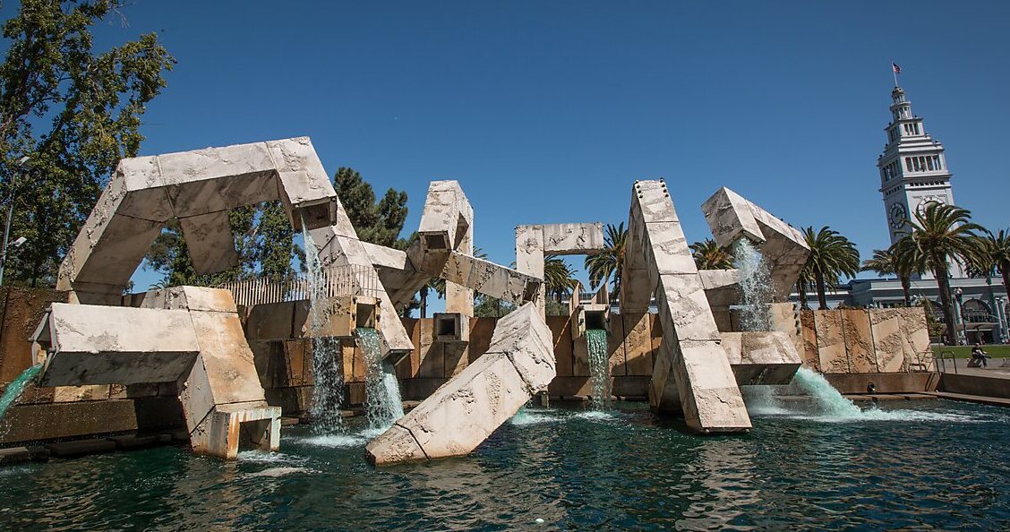
Armand Vaillancourt's 1971 fountain in Justin Herman Plaza is forty feet of raw concrete forms that look, depending on your disposition, either like a brutalist fever dream or like the most honest public art in the city. It has been controversial since the day it was installed — critics called it ugly, admirers called it uncompromising, and the city has periodically discussed removing it. What everyone agrees on is that it produces a genuinely extraordinary sound: water moving through angular concrete passages creates a white noise that somehow insulates the plaza from the surrounding Financial District. Vaillancourt spray-painted the words 'Quebec libre!' on the structure during a 1990 concert, which earned him a citation but also made the fountain briefly front-page news. It remains the only major public artwork in San Francisco that actively provokes rather than reassures.
Il consiglio del team
Stand inside the fountain's lower passages when the water is running and the acoustic effect is unlike anything else in the city. The plaza is quietest on weekend mornings, when the Financial District empties out.
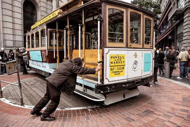
The cable cars have been running since 1873, which means they predate the automobile, the airplane, and most of the city's current building stock. What the postcard version doesn't convey is the engineering logic underneath: a continuous loop of cable runs through a slot in the street at a constant nine and a half miles per hour, and the gripman's entire skill consists of knowing exactly when to grip and when to release. The cars don't have engines. They borrow momentum from something moving perpetually beneath the road, which is either a metaphor for the city's relationship with its own history or simply a very clever solution to the problem of steep hills. The Powell-Hyde line offers the most varied topography; the California Street line is less photographed and carries more actual commuters.
Il consiglio del team
Board at an intermediate stop rather than the turnaround terminus to avoid the longest queues. The outside running boards offer the full kinetic experience, though they require some grip strength on the steeper descents.
The distinction between the cable car as tourist spectacle and the cable car as functional transit is worth dwelling on. San Francisco's century-old network was introduced in 1873 to replace horse-drawn streetcars and underwent a comprehensive restoration in the 1980s that preserved the original mechanical character while bringing the infrastructure up to modern safety standards. The outside platforms — the running boards along the sides — are where the ride becomes something other than a museum exhibit. You're moving through the city at the speed of a fast walk, close enough to touch the buildings, subject to the same gradients that shaped the street grid. Regular commuters still use the California Street line in the early morning, and the atmosphere at 7am is entirely different from the midday tourist experience.
Il consiglio del team
The Cable Car Museum on Mason Street is free and shows the actual working machinery — the giant sheaves pulling the cables under the city. It is one of the few places in San Francisco where you can see the infrastructure that makes a landmark possible.
The Golden Gate park occupies 1,017 acres of what was, in the 1860s, a largely uninhabitable stretch of sand dunes known as the Outside Lands. The transformation into a functioning urban park required decades of soil engineering and plant science, and the result is a landscape that feels ancient and inevitable despite being entirely constructed. It is the heart of the city in a way that the more famous landmarks are not — locals use it for football, tai chi, drum circles, and the particular San Francisco ritual of lying in the grass while pretending the fog isn't coming. The park contains a buffalo paddock, a Dutch windmill, a Japanese tea garden, and a children's carousel, none of which appear on the standard tourist itinerary.
Il consiglio del team
The buffalo paddock near the park's western end is genuinely surprising to encounter in the middle of a major city. Early morning visits to the Strybing Arboretum within the park offer a level of quiet that the rest of the city rarely provides.
The 412 hectares of Golden Gate Park are understood by most visitors as the area between the de Young Museum and the California Academy of Sciences — a cultural campus with grass between the buildings. What they miss is the park's western half, which runs all the way to the Pacific Ocean and contains meadows, lakes, and gardens that see a fraction of the eastern end's foot traffic. The Panhandle — the narrow strip extending east toward the Haight — is where the neighbourhood actually lives, where dogs and cyclists and skaters negotiate a shared corridor. The park's relationship with the surrounding residential neighbourhoods is its most interesting quality: it doesn't function as an escape from the city but as its connective tissue.
Il consiglio del team
The Chain of Lakes in the park's western section is almost entirely unknown to visitors. On a weekday afternoon, you can have a lakeside bench to yourself within a twenty-minute walk of the Haight Street buses.
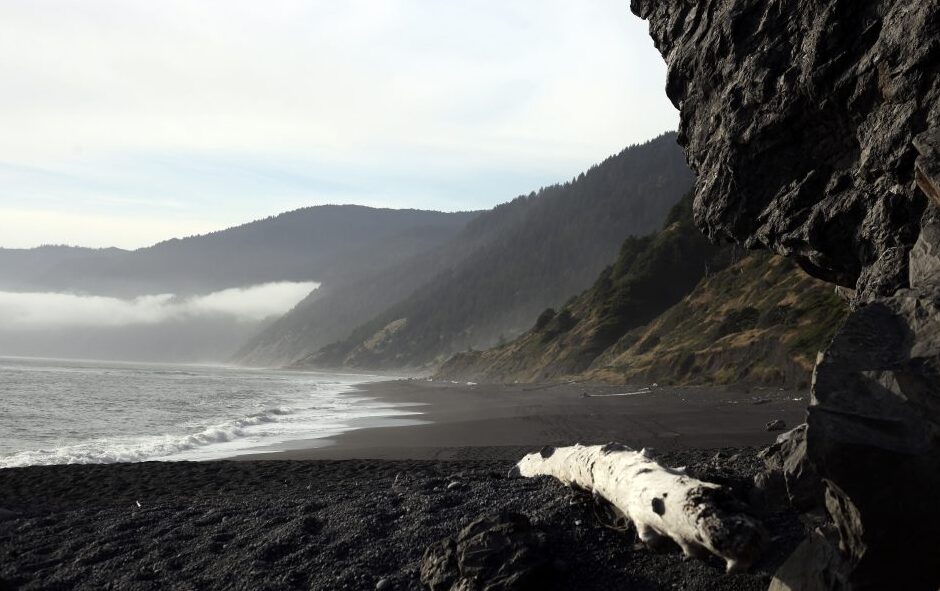
California has trained the world to expect a particular kind of beach: blonde sand, reliable sun, the infrastructure of leisure. Black Sands Beach, tucked into the Marin Headlands north of the Golden Gate, refuses all of that. The sand is dark, almost charcoal, the result of erosion from the surrounding serpentine and basalt cliffs, and the water temperature discourages anything beyond wading. The hike down from the trailhead is steep enough to keep casual visitors away, and the beach itself has a wild, almost northern European quality — the kind of place where the landscape is clearly indifferent to your comfort. On a clear day, the view back toward the Golden Gate is one of the most compositionally interesting in the Bay Area, precisely because it reverses the usual angle.
Il consiglio del team
The trailhead is accessible from Conzelman Road in the Marin Headlands. Go on a weekday if possible — weekend hikers from the city have begun discovering it, and the solitude is the point.
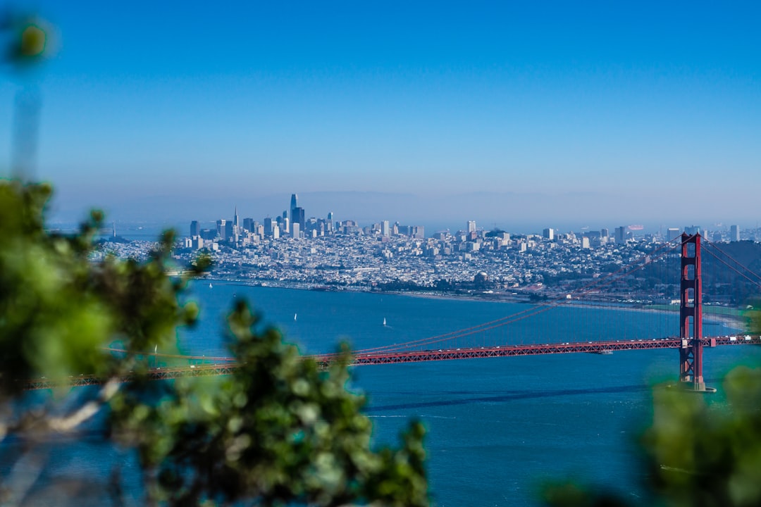
The Golden Gate Bridge connects San Francisco to Marin County across a strait that was considered unbridgeable for decades, and the engineering argument for its existence was largely economic — the ferry system was inadequate for the region's growth. What it became, of course, is something else entirely: a structure so photogenic that it has effectively replaced the city itself as the primary mental image of San Francisco worldwide. What gets lost in the iconography is the physical experience of the bridge at close range — the scale of the towers, the sound of wind through the cables, the way the roadway vibrates slightly under foot traffic. Walking the pedestrian path on a clear morning, when the bay is visible in both directions and the city sits behind you in the fog, is an experience that the photographs consistently fail to capture.
Il consiglio del team
The north tower's viewing area in Marin County offers a perspective on the bridge that most visitors never see — looking south toward the city with the full span in front of you. Accessible by bicycle via the bridge itself.
San Francisco's Chinatown is the oldest in North America, established in the 1840s, and it survived the 1906 earthquake — which destroyed most of the surrounding city — primarily because its residents rebuilt faster than anyone else. The neighbourhood that exists today is layered in a way that the tourist-facing Grant Avenue doesn't reveal: the herbalists and acupuncture practitioners on Stockton Street operate according to a different logic than the souvenir shops one block over. The temples, the clan associations, the social infrastructure of a community that has been here longer than most of the city's other institutions — these are present if you're willing to walk slowly and look at the buildings rather than the shop fronts. The neighbourhood is not performing authenticity for visitors. It is simply continuing.
Il consiglio del team
Stockton Street, one block west of Grant Avenue, is where the neighbourhood does its actual shopping. The produce markets and dried goods stores operate on a scale and at prices that have nothing to do with tourism.
Sausalito developed rapidly as a shipbuilding centre during World War II, and in the postwar years that industrial character gave way to something more complicated: a reputation as an artists' community, then as a wealthy enclave, then as both simultaneously. The houseboat community that developed in Richardson Bay after the war is one of the most unusual residential landscapes in the United States — several hundred homes floating on the water, some of them architectural experiments, some of them simply eccentric. The main street caters visibly to day-trippers from the city, but the residential streets above the waterfront have a quieter quality, and the ferry crossing from San Francisco is one of the better twenty-minute journeys available in the Bay Area.
Il consiglio del team
The houseboat community at the northern end of Sausalito, accessible on foot from the main waterfront, is a working neighbourhood rather than an attraction. Walk through respectfully and the architecture will reward the attention.
The California Academy of Sciences was founded in 1853, making it one of the oldest scientific institutions in the western United States and one of the few places in the country where a natural history museum, planetarium, and aquarium occupy the same building. The research function is genuine — the Academy employs working scientists and conducts active field research — and this distinguishes it from institutions that have gradually become primarily entertainment venues. The living coral reef exhibit in the basement aquarium is one of the largest in the world, and the four-story rainforest dome that rises through the building's centre contains free-flying birds and butterflies in a controlled tropical environment. The scientific seriousness and the showmanship coexist without apparent tension.
Il consiglio del team
The Academy's rooftop is partially visible from the Music Concourse for free. Inside, the basement aquarium is noticeably less crowded in the late afternoon when families with young children begin to leave.
San Francisco in 2026 rewards visitors who approach it with some preparation, not because it is difficult but because the city's geography — hills, microclimates, neighbourhoods that shift character within a single block — means that the difference between a good day and a frustrating one is often a matter of logistics. The transit system, BART and Muni combined, covers the city comprehensively but requires some understanding of the fare system and the route logic. The microclimates are real: the Inner Sunset can be fifteen degrees colder than the Mission on the same afternoon, and packing accordingly is the single most practical piece of advice for any visit. Digital tools for navigation, transit timing, and neighbourhood research have improved substantially, and using them actively rather than defaulting to a single mapping application tends to surface options that the algorithm-driven tourist trail misses.
Il consiglio del team
The Muni Metro underground stations connect the Castro, the Inner Sunset, and downtown with surprising efficiency. The N-Judah line to Ocean Beach is one of the city's best transit journeys and is used almost exclusively by locals.
Cities reward the second look more than the first. San Francisco is particularly good at this — it has enough visual drama in its standard-issue version to satisfy a short visit, and enough depth in its overlooked corners to occupy years of serious attention. The places on this list are not secrets in any strict sense. The cable cars appear on every itinerary. The Golden Gate Park is on every map. What changes is the quality of attention you bring to them, and the willingness to stand still long enough for the place to become something more than a confirmation of what you already expected to find. The fog will come in the afternoon regardless of your plans. The hills will be steeper than you remembered. The city will continue being exactly itself, indifferent to whether you've understood it or not. That indifference, more than any particular landmark, is what makes San Francisco worth returning to.
★ Guida tascabile
Porta questa guida con te.
Salvala offline, ottieni le indicazioni a piedi e scopri migliaia di luoghi come questi.
What is the best way to get between San Francisco and Sausalito?
The Golden Gate Ferry from the Ferry Building at the foot of Market Street is the most practical option and also the most enjoyable — the crossing takes approximately thirty minutes and provides a perspective on the bay and the city skyline that no land-based transit can replicate. Ferries run regularly on weekdays and weekends, though schedules thin out in the evenings. Bicycle rental in San Francisco allows you to cycle across the Golden Gate Bridge and ride down into Sausalito, returning by ferry with your bike — a well-established route that takes approximately two to three hours depending on fitness and how long you linger.
Is the Vedanta Temple open to visitors, and are there any dress requirements?
The Vedanta Temple in the Western Addition is generally open to visitors who wish to view the architecture and attend public programs, though hours vary and it is advisable to check the temple's current schedule before visiting. As with most active religious sites, modest dress is appropriate — shoulders and knees covered is a reasonable baseline. The temple is an active place of worship rather than a museum, so visitors should expect to be respectful of ongoing religious activity. The exterior architecture is fully visible from the street at any time and is worth examining in detail from the pavement opposite.
How crowded does Golden Gate Park get, and when is the best time to visit?
Golden Gate Park receives millions of visitors annually, but the crowds concentrate in the eastern section around the de Young Museum, the California Academy of Sciences, and the Japanese Tea Garden, particularly on weekends. The park's western two-thirds — the Chain of Lakes area, the buffalo paddock, and the approaches to Ocean Beach — see dramatically less foot traffic at almost any time. Weekday mornings before 10am are the quietest period across the entire park. The park also hosts major events, particularly in summer, which can affect specific areas; checking the city's events calendar before visiting allows you to avoid or deliberately seek out these gatherings.
Is Black Sands Beach safe to visit, and how difficult is the access?
Black Sands Beach in the Marin Headlands is accessible via a moderately steep trail from Conzelman Road and requires reasonable physical fitness — the descent and return climb takes approximately thirty to forty-five minutes combined. The beach itself carries standard coastal hazards: the water is cold, currents can be strong, and swimming is not recommended. The trail is well-marked and maintained by the Golden Gate National Recreation Area. Driving to the Marin Headlands requires crossing the Golden Gate Bridge; the Marin Headlands are accessible by bicycle via a dedicated path, and a seasonal shuttle operates from the Sausalito ferry terminal on weekends.
Does SFMOMA offer any free or reduced-price admission options?
SFMOMA offers free admission to visitors aged 18 and under, which is a genuine institutional commitment rather than a token gesture. The museum periodically offers free or discounted admission on specific evenings — the Thursday NightLife format at the California Academy of Sciences has a parallel at SFMOMA with evening programming that tends to draw a different audience than the standard daytime visit. San Francisco residents can access reduced admission through various local programs. The museum's ground-floor galleries and the café are accessible without a ticket, allowing visitors to experience the Botta building's atrium and ground-level public spaces at no cost.
★ Leggila quando vuoi
Salvala sul tuo telefono.
Aggiungi questa guida ai preferiti, pianifica il viaggio offline, scopri luoghi come questi.