10 Best Day Trips from Boston — by train, car, and boat
Practical routes, honest timing, and what actually makes each one worth your day
L
Una guida di
Lena Hofmann
Aggiornata il
29 maggio 2026
Lettura
12 minuti
Comprende
10 luoghi · mappa interattiva
★ Guida d'Italia 2026
Pianifica con cura. Viaggia più a fondo.
1.3M+ luoghi curati nel mondo, mappe offline e itinerari intelligenti — tutto in un'app gratuita.
1.3M+ luoghiMappe offlineItinerari AIGratis
Boston is a city that rewards people who leave it. That sounds like a contradiction, but anyone who has lived here long enough knows what I mean. The T gets crowded, the parking is an ongoing argument between you and the universe, and the neighborhoods — as good as they are — can start to feel like a loop after a while. The surrounding region, though, is genuinely varied in a way that a lot of American metro areas aren't. Within two hours of South Station or North Station, you can be standing on a glacially carved cliff above the Atlantic, walking through a reconstructed 17th-century Pilgrim settlement, or watching a humpback whale surface close enough to hear it breathe. That range is not accidental. New England compressed a lot of geography and history into a small footprint.
A good day trip, in my view, satisfies three conditions. First, the travel itself shouldn't eat the day — if you're spending four hours in a car for three hours on the ground, you've made a scheduling error. Second, the destination has to offer something you genuinely cannot replicate in the city. A different coastline, a different century, a different pace. Third, the logistics have to be survivable. That means knowing when the crowds arrive, where to park if you're driving, and whether the last train home gives you enough time to actually eat dinner somewhere.
I've done every trip on this list multiple times, by different means. Some I've done wrong before I figured out how to do them right. The notes that follow are the result of those mistakes.
Stellwagen Bank sits roughly 25 miles east of Boston, a submerged plateau at the mouth of Massachusetts Bay where cold, nutrient-rich water wells up from depth and creates one of the more productive feeding grounds on the East Coast. Whale-watching vessels depart from Boston's Long Wharf and from Provincetown; the Boston departure takes about 90 minutes each way on a fast boat, which sounds like a lot until a fin whale the length of a school bus surfaces 40 feet off the bow. The sanctuary covers 842 square miles and is federally protected — no extractive fishing, no drilling. Humpbacks are the most reliably sighted species from late spring through early fall, and they're theatrical feeders, often bubble-net feeding in coordinated groups. Beyond the whales, you'll see northern gannets, storm petrels, and occasionally Atlantic white-sided dolphins riding the bow wake. The boat itself is part of the experience: standing on the upper deck in 20-knot wind, watching the Boston skyline shrink behind you, recalibrates something.
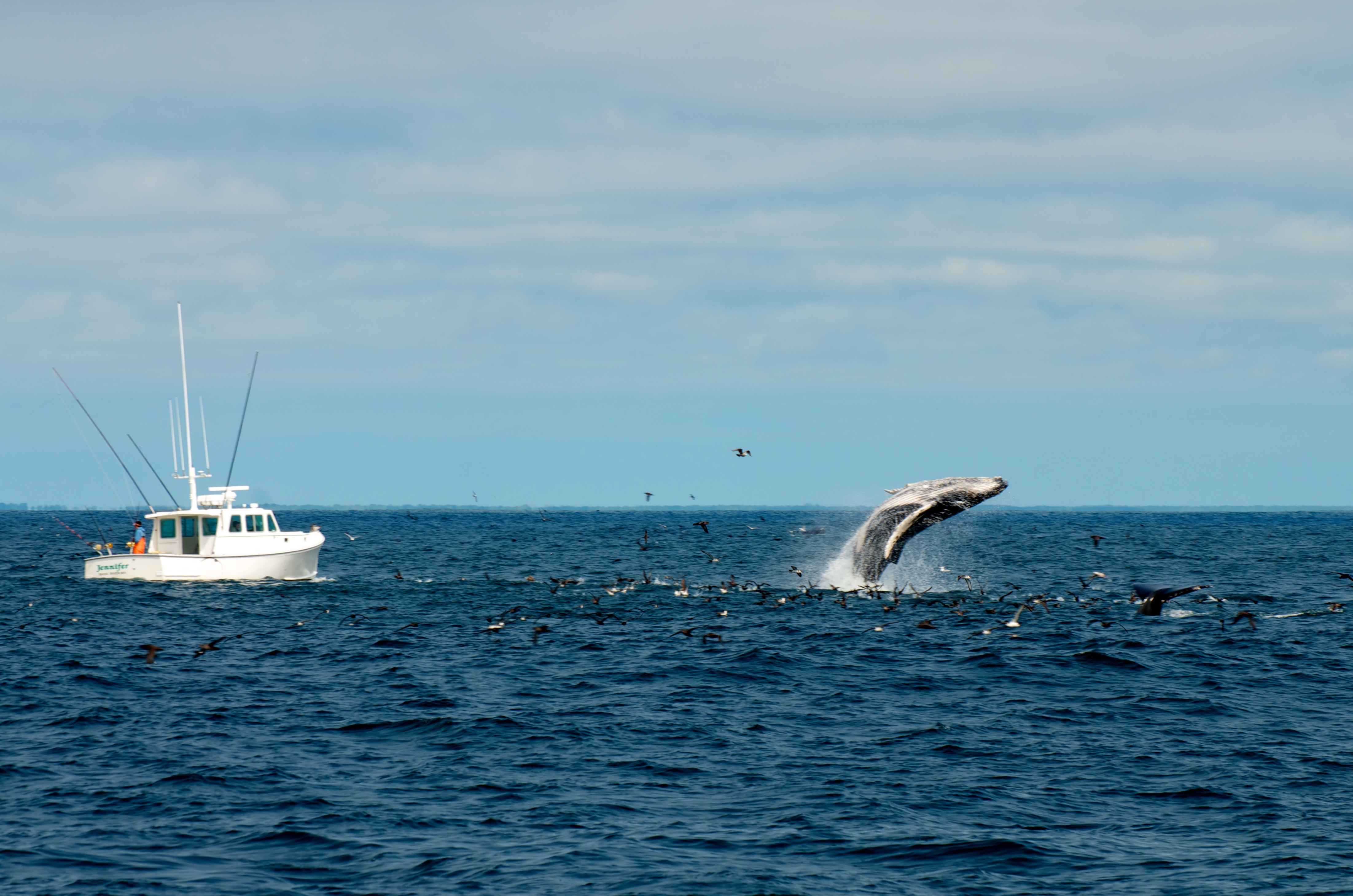
On arrival (or rather, on the water): watch for bubble-net feeding clusters, track the naturalist's narration for species ID, scan the horizon for spouts before the boat reaches them, and pay attention to the return leg — animals are often more active in the late afternoon.
Il consiglio del team
Book the first departure of the day, typically 9 or 10 a.m. The water is usually calmer before afternoon sea breezes build, and the whales haven't been circled by a dozen boats yet. If you're prone to seasickness, take medication the night before — not the morning of. The crossing to the bank is open-ocean chop, not harbor chop.
Provincetown sits at the absolute tip of Cape Cod, a narrow curl of land that took its current shape from glacial retreat roughly 10,000 years ago. The fast ferry from Boston's World Trade Center pier covers the 60-mile crossing in about 90 minutes — and that crossing matters, because arriving by water is the correct way to arrive. The town appears slowly: the Pilgrim Monument rising above the rooftops, the harbor crowded with fishing boats and pleasure craft, the low dunes behind everything. Provincetown has been an artists' colony since the early 20th century, when painters and writers discovered its particular quality of light, and it has been a significant LGBTQ destination for decades — both identities coexist in a place that is genuinely tolerant in the way that only very small, very self-selected communities can be.
Four things to do with your hours on the ground: walk Commercial Street end to end (it's the main drag and it's walkable in 20 minutes, but you'll stop constantly), climb the Pilgrim Monument for the view across the outer Cape, spend an hour in one of the serious commercial galleries on the east end of town, and sit at the harbor's edge with something cold before the return ferry.
Il consiglio del team
The fast ferry sells out on summer weekends — book two to three weeks ahead. The last ferry back to Boston typically departs around 6 p.m.; confirm the exact time when you book, because missing it means a two-hour drive or an overnight you didn't plan for. Shoulder season — late September, early October — is when the town is most itself: quieter, cooler, still beautiful.
Plymouth Light, also called Gurnet Light, was established in 1768, which makes it one of the oldest lighthouse sites in the country, and the structure standing today is widely cited as the oldest freestanding wooden lighthouse in the United States. It sits on a narrow peninsula called the Gurnet, at the northern edge of Plymouth Bay, accessible by a causeway that floods at high tide — which is one of the reasons this place stays quiet even when Plymouth itself is packed with tourists. The drive from Boston is about an hour south on Route 3. Plymouth the town is worth a walk — the harbor is genuinely historic and the Mayflower II replica is moored there — but the lighthouse is the reason to come specifically.
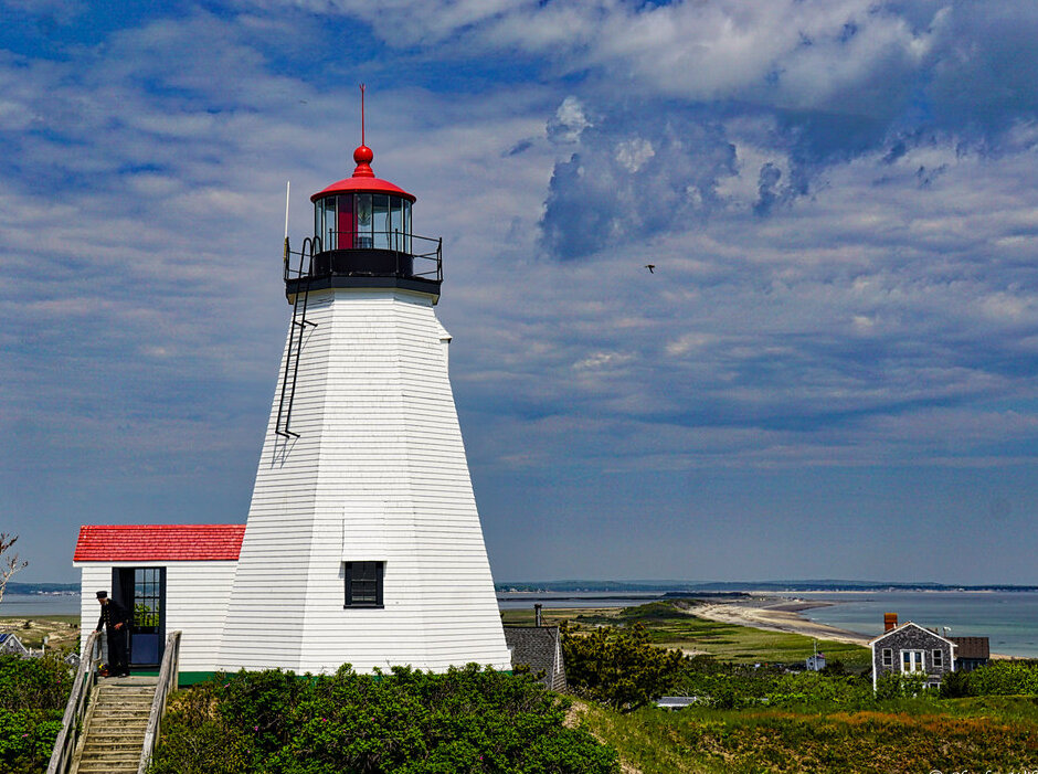
Four things to do: time your arrival to walk the Gurnet at low tide, photograph the lighthouse from the beach below (the wooden structure against open sky is a more honest image of early American maritime life than anything in a museum), check whether the lighthouse is open for guided access on the day you visit, and walk the barrier beach south toward Duxbury for a stretch of coast that feels genuinely remote.
Il consiglio del team
Check tide tables before you go. The causeway to the Gurnet can be impassable at high tide, and if you time it wrong, you either wait two hours or turn around. The Plymouth Visitors Bureau website typically posts access conditions, but a quick check of NOAA tide predictions for Plymouth Harbor is more reliable.
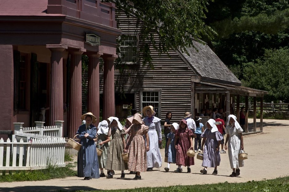
4Living history museum|Archaeological site· 58.8 km
Plimoth Plantation — the spelling is deliberate, an archaic rendering — is a full-scale reconstruction of the Plymouth Colony as it existed in 1627, seven years after the Mayflower landing. Interpreters in period dress speak in character, in period-appropriate English, and they will not break character to answer your phone. That sounds gimmicky until you're actually standing in a wattle-and-daub house watching someone explain, in 17th-century syntax, why the harvest was poor. The museum also includes a Wampanoag Homesite, staffed by Indigenous interpreters who speak in their own voice — not in character — about Wampanoag history and culture before and after European contact. That distinction matters and the museum is deliberate about it.
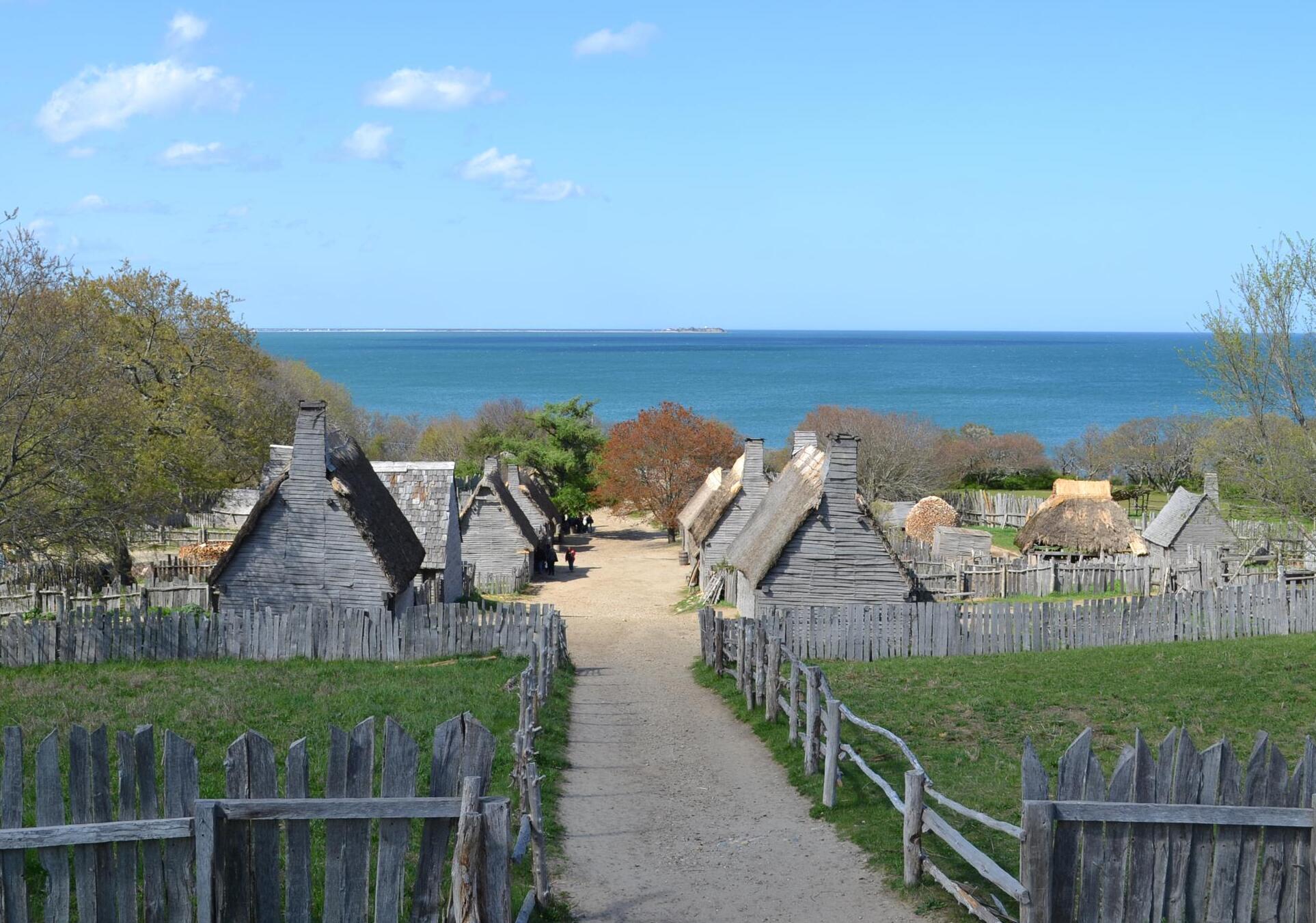
The drive from Boston is about an hour on Route 3. Four things to do: spend at least 45 minutes in the Wampanoag Homesite before the Colonial Village (the sequencing changes how you read everything), ask the interpreters about the specific political tensions of 1627, walk the full perimeter of the settlement, and allow time for the main exhibition building, which provides context the outdoor spaces assume you have.
Il consiglio del team
Arrive when the gates open, typically 9 a.m. School groups arrive in waves between 10 and 11 a.m. and the Colonial Village becomes genuinely difficult to navigate. If you're visiting with children, that overlap can be fine — if you're trying to have a real conversation with an interpreter, it isn't. The site requires a full half-day minimum; don't try to combine it with the lighthouse on the same morning.
Old Sturbridge Village sits about 65 miles west of Boston on the Massachusetts Turnpike, roughly an hour's drive depending on traffic through the Framingham corridor. It reconstructs rural New England life between the 1790s and 1830s — a period that tends to get skipped in popular history, which jumps from the Revolution to the Civil War and misses the decades in between when the country was actually figuring out what it was. The village covers about 200 acres and includes more than 40 historic structures, some original to the site and some relocated from elsewhere in New England. Costumed interpreters demonstrate period trades: printing, blacksmithing, pottery, farming. The pace is intentionally slow, which is either the point or a problem, depending on your temperament.
Four things to do: watch the working farm in the morning when the animals are active, spend time in the printing office and ask about the mechanics of early American newspaper production, walk the millpond loop in the afternoon light, and check the daily program board at the entrance for any scheduled demonstrations — some happen only once a day.
Il consiglio del team
OSV is genuinely worth a full day, and most people don't give it one. If you're driving from Boston, leave by 8:30 a.m. to beat the Framingham traffic and arrive at opening. The village can be muddy after rain — wear shoes you don't mind getting dirty. The on-site restaurant serves period-inspired food and is better than you'd expect from a museum cafeteria.
Rhode Island is the smallest state in the country and Providence is its capital — a city with a genuinely distinct identity that doesn't get nearly enough attention from Boston day-trippers, possibly because it's only 50 miles south on I-95 and people assume proximity means similarity. It doesn't. Providence has its own architectural character (Federal Hill, College Hill, the riverfront), its own art scene anchored by the Rhode Island School of Design, and its own food culture. The frozen lemonade is the entry point to that last category: it's a Rhode Island institution, a specific preparation — not a slushie, not a granita — that you find at Del's Frozen Lemonade stands throughout the state. It's a summer ritual, and it's worth taking seriously as a piece of regional food culture.
Four things to do: walk Benefit Street on College Hill for one of the best concentrations of 18th and 19th-century architecture in New England, spend an hour in the RISD Museum, eat on Federal Hill (the Italian-American neighborhood with serious restaurants), and find a Del's stand for the frozen lemonade before you drive home.
Il consiglio del team
I-95 south from Boston on a Friday afternoon is a genuine ordeal. If you're going on a weekend, leave Boston before 9 a.m. or after 7 p.m. on Friday. Amtrak's Northeast Regional stops at Providence Station in about 45 minutes from South Station — for this destination, the train is faster and less stressful than driving, and Providence Station puts you within walking distance of most of what matters.
Clingstone is a house built in 1905 on a small rocky island called Dumpling Rock in Narragansett Bay, near Jamestown, Rhode Island. The architect was J.D. Johnston, and the structure — a shingled Victorian pile perched directly on exposed granite — looks like something a child would draw if asked to imagine the most improbable house possible. It is privately owned and not open to the public in the conventional sense, but it is visible from the water, and kayak tours of Narragansett Bay pass close enough to read the details. The house has been maintained and expanded by successive generations of the same family, which is itself an unusual story in an era when most buildings of this type have been institutionalized or demolished.
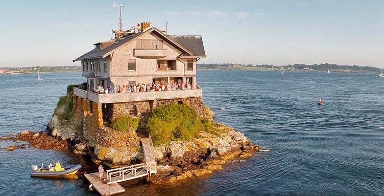
Four things to do: book a kayak tour from Jamestown or Newport that routes through the bay past Clingstone, photograph the house from the water at different distances, explore Jamestown itself (the village on Conanicut Island is undervisited and has good food), and time the return to catch the sunset over the bay from Fort Wetherill State Park.
Il consiglio del team
This is a 90-minute drive from Boston on a good day, longer on summer weekends when Route 138 across the Jamestown Bridge backs up. Go on a weekday if you can. The kayak tours that pass Clingstone book up quickly in July and August — reserve at least a week ahead. If you're not kayaking, the view from Jamestown's shoreline gives you a clear sightline across the bay.
Cape Cod is a glacial peninsula — a terminal moraine left by the Laurentide Ice Sheet — and once you understand that, the landscape starts to make sense: the kettle ponds, the rolling outwash plains, the thin barrier beaches that are actively migrating westward. The Cape is about 70 miles from Boston by road, but the Sagamore Bridge is a chokepoint that can turn a 90-minute drive into three hours on a summer Friday afternoon. The Cape Cod National Seashore, established in 1961, protects the outer Cape's most dramatic coastline — 40 miles of Atlantic-facing beach with dunes up to 150 feet high. The towns along Route 6A (the Old King's Highway) on the bay side are architecturally intact in a way that the Route 28 towns on the south shore are not.
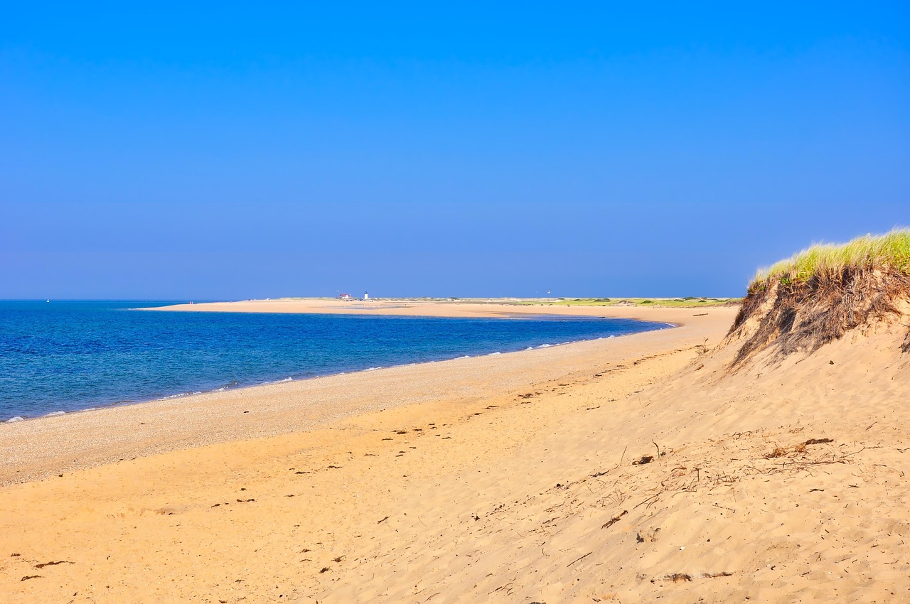
Four things to do: drive Route 6A from Sandwich to Brewster and stop at the Cape Cod Museum of Natural History in Brewster, walk the Great Island Trail in Wellfleet (a 4-mile loop through salt marsh and barrier beach), swim at Coast Guard Beach in Eastham (one of the better Atlantic-facing beaches in the Seashore), and stop at the Nauset Light overlook at dusk.
Il consiglio del team
The Sagamore and Bourne bridges are the only road crossings onto the Cape. On summer Fridays, both are backed up by noon. Leave Boston before 8 a.m. or after 8 p.m. on Fridays. Parking at the National Seashore beaches fills by 9:30 a.m. on peak summer days — the Seashore sells day passes and they go fast. The shoulder season (late September through October) is when the Cape is most navigable and the light is best.
The Aquinnah Cliffs, also known as the Gay Head Cliffs, rise roughly 150 feet above the Atlantic on the western tip of Martha's Vineyard, and they are one of the more visually arresting pieces of geology in New England — not because they're large by global standards, but because the layering is so explicit. The cliffs expose sediment deposited over millions of years, compressed and tilted by glacial pressure, and the color banding — white, gray, red, brown — reads like a stratigraphy textbook left open in the sun. The Aquinnah Wampanoag Tribe has stewarded this land for centuries, and the cliffs carry cultural significance that predates European settlement by a very long margin. Getting here from Boston requires a ferry to the Vineyard (from Woods Hole, about 45 minutes) and then a 20-mile drive or bus ride to the western tip of the island.
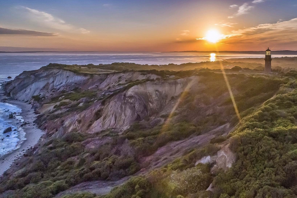
Four things to do: walk the path above the cliffs at different times of day (the color shifts dramatically), visit the Aquinnah Cultural Center for context on Wampanoag history, walk the beach below the cliffs at low tide, and allow time to explore the small Aquinnah village before heading back east toward the ferry.
Il consiglio del team
The ferry from Woods Hole to Vineyard Haven runs year-round but books up completely on summer weekends — reserve vehicle passage months in advance, or leave your car in Falmouth and walk on as a foot passenger (much easier to book). The Vineyard Transit Authority bus runs from Vineyard Haven to Aquinnah, which removes the parking problem at the cliffs entirely. Last ferry back to the mainland is late evening, but check the Steamship Authority schedule on the day you travel.
La Casa di Carta — the Paper House — is exactly what the name says: a house in Rockport, Massachusetts, constructed almost entirely from paper, including the furniture inside. Built by mechanical engineer Elis Stenman starting around 1922, the structure used rolled and varnished newspapers as its primary building material, and the walls are reportedly more than an inch thick with compressed paper. Stenman continued adding to it for decades, constructing furniture from newspaper rolls as well. It's a small structure — more of a curiosity than a destination in the conventional sense — but it represents a particular strain of American folk ingenuity that is worth encountering in person. Rockport itself, on Cape Ann about 40 miles north of Boston, is a working fishing village that has also been an artists' colony since the 19th century. The Paper House is a short detour from the village center.
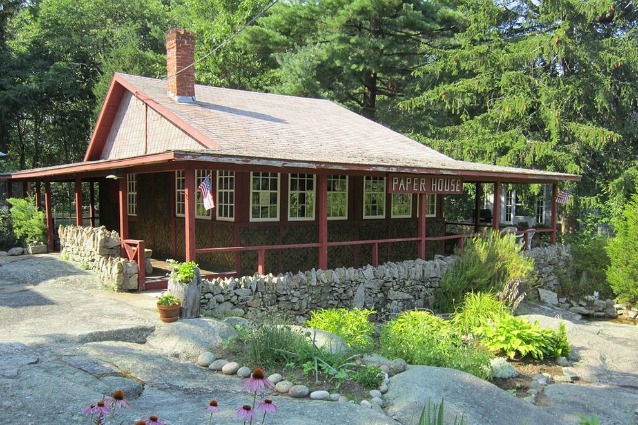
Four things to do: examine the Paper House construction closely (the layering technique is more sophisticated than it sounds), walk Bearskin Neck in Rockport village, spend time at Halibut Point State Park on the northern tip of Cape Ann for views of the Ipswich Bay, and drive the scenic loop around Gloucester on the way back.
Il consiglio del team
The Paper House is a private attraction with limited hours — verify opening times before you go, as it has historically been seasonal and staffed by volunteers. It's a 20-minute detour from Rockport center, and the drive along Route 127 around Cape Ann is itself a reason to come. Rockport parking fills quickly on summer weekends; the commuter rail from North Station to Rockport (about 70 minutes) is a genuinely better option than driving in July or August.
The thing about day trips is that they change your relationship to the place you live. Boston is easier to appreciate when you've been away from it for eight hours — when you come back over the Zakim Bridge at dusk and the harbor is catching the last light. But the trips themselves do something independent of that: they remind you that the region has depth, that the history here is layered and contested and still being argued over, that the coastline is doing something geologically active whether you're watching or not.
None of these trips require a lot of money or a lot of planning. They require a willingness to leave early, to check the tide tables or the ferry schedule, to resist the impulse to cram three destinations into one day. The best version of any of these trips is the one where you get somewhere, slow down, and actually look at what's in front of you. That's a discipline, not a given. But Boston makes it easy to practice.
★ Guida tascabile
Porta questa guida con te.
Salvala offline, ottieni le indicazioni a piedi e scopri migliaia di luoghi come questi.
What's the best time of year for day trips from Boston?
It depends on the destination. For whale watching on Stellwagen Bank, late spring through early October is the reliable window, with July and August offering the most consistent sightings. For Cape Cod and the islands, late September through mid-October is objectively better than peak summer — the roads are clear, the parking is available, and the weather is usually stable. For inland destinations like Old Sturbridge Village or Plimoth Plantation, spring and fall are ideal; summer heat and school groups make July and August the most difficult months. Winter trips to the coast (Rockport, Plymouth) are underrated if you dress for them — the light is different and the crowds are gone entirely.
Is there a train pass that covers these destinations?
The MBTA Commuter Rail serves several of these destinations directly. A standard one-way fare from South Station or North Station covers most routes, and the MBTA sells weekend passes that allow unlimited travel on the commuter rail for a flat fee — worth calculating against two round-trip fares. For Providence, Amtrak's Northeast Regional is faster than the MBTA and the fare is competitive, especially if booked in advance. There is no single pass that covers all ten destinations on this list; the boat trips (Stellwagen Bank, Provincetown ferry) are operated by private companies and priced separately. The Steamship Authority ferries to Martha's Vineyard are also separate and should be booked well in advance for summer travel.
Which of these trips are feasible without a car?
More than you'd think, but with caveats. Provincetown is excellent by fast ferry from Boston — no car needed. Stellwagen Bank whale watching departs from Boston Harbor. Providence is better by train than by car. Rockport (for the Paper House) is served by the MBTA commuter rail from North Station. Plymouth is reachable by commuter rail from South Station, though getting from Plymouth station to Plimoth Plantation or the Gurnet requires a taxi or rideshare. Martha's Vineyard is accessible by ferry as a walk-on passenger, and the Vineyard Transit Authority bus runs to Aquinnah. Old Sturbridge Village is the hardest without a car — there's no practical transit connection from Boston.
What are the most common mistakes people make on these day trips?
Leaving too late is the most common error, especially for anything involving a bridge (Cape Cod), a ferry (Martha's Vineyard, Provincetown), or a parking lot that fills by 10 a.m. (National Seashore beaches). The second mistake is trying to combine two destinations in one day — Plymouth Light and Plimoth Plantation sound like a natural pairing, but they're on opposite sides of Plymouth Bay and the logistics eat your time. The third mistake is not checking operating hours in advance; several of these sites (the Paper House, Plimoth Plantation, Old Sturbridge Village) have seasonal schedules and are closed certain days of the week. Verify hours the day before you go, not the morning of.
Are any of these trips suitable for young children?
Yes, several. Plimoth Plantation is well-designed for children — the living history format holds attention in a way that conventional museums don't, and the farm animals are a reliable draw. Old Sturbridge Village is similarly child-friendly, with hands-on demonstrations and enough physical space to move around. The Stellwagen Bank whale watch is excellent for children old enough to handle 90 minutes on open water without getting seasick (roughly 8 and up, though it varies). The Aquinnah Cliffs on Martha's Vineyard require a ferry crossing and a bus ride, which some children find exciting and some find exhausting — know your child. The Paper House in Rockport is a short visit but genuinely captures children's imaginations in a way that more conventional historic sites sometimes don't.
★ Leggila quando vuoi
Salvala sul tuo telefono.
Aggiungi questa guida ai preferiti, pianifica il viaggio offline, scopri luoghi come questi.